


About PIRATA
The experimental program PIRATA (initially « Pilot Research moored Array in the Tropical Atlantic » and named « Prediction and Research Moored Array in the Tropical Atlantic » from 2008) has been implemented in 1997 in the Tropical Atlantic Ocean (Servain et al. 1998). It has been launched in the framework of the international program CLIVAR (CLImatic VARiability and predictability) and implies scientific teams from three countries: France (IRD, Météo France, with contributions by IFREMER and CNRS/INSU), Brazil (DHN and INPE) and USA (NOAA/PMEL). Financial supports for the program are from the IRD, Météo France, and and occasionally from Observatoire Midi-Pyrénées/Université Paul Sabatier.
In France, the coordination is ensured by the UMR LEGOS and the realisation of the annual oceanographic cruise and operations is ensured by the US191 IMAGO.The more specific goals of the PIRATA program are:
- What are the forcing and coupling mechanisms between the atmospheric and oceanic components on the Tropical Atlantic in particular, what are the Sea Surface Temperature (SST)'s control mechanisms and what are those of heat fluxes?
- What are the influences of these heat fluxes (and of quantities of movement: the wind) on the variability (position and intensity) of the trade winds Inter-Tropical Convergence Zone (ITCZ) and on the convective systems of the Gulf of Guinea (which is of interest to the West African monsoon), and on those of the western region of the basin (which is of interest to rainfall over South America and to hurricanes over West Indies)?
- What is the relationship between the variability of the SST and that of the heat content of the Tropical Atlantic, and what is its influence on the various variability modes in this region? In particular, what is the dynamic link between the north and south poles of the meridian variability mode of the Atlantic and between it and the equatorial mode?
- What are the teleconnections and their mechanisms between the variability in the Tropical Atlantic region and that in other regions (El Niño Southern Oscillation -ENSO-, North Atlantic Oscillation -NAO-, South Atlantic variability etc.)?
In this framework, the overarching goals of PIRATA are to:
- improve the description of the intra-seasonal to interannual variability in the atmospheric and oceanic (from the surface down to 500m depth) boundary layers in the tropical Atlantic;
- improve our understanding of the relative contributions of air-sea fluxes and ocean dynamics to variability in sea surface temperature (SST) and sub-surface heat content at intra-seasonal to interannual time scales;
- provide a set of data useful for developing and improving the predictive models of the ocean-atmosphere coupled system;
- document interactions between tropical Atlantic climate and variability outside the region, (e.g. ENSO or the North Atlantic Oscillation);
- maintain (and, if possible, enhance) an array of moored oceanic buoys and collect and transmit a set of oceanic and atmospheric data, via satellite in real-time, to monitor and study the upper ocean and atmosphere of the tropical Atlantic, and provide in situ data to operational systems.
After a "pilot phase" from 1997 to 2001, the institutions in the three supporting countries decided to extend the array maintenance for a 5-year "consolidation phase" to allow for a meaningful demonstration that the data would contribute significantly to both scientific research and operational applications. This "consolidation phase" has been extended until February 2008. A PIRATA Resources Board (PRB) has been established in 1999 to answer to the objectives of the commitments (financial, human, vessel time...) signed between involved institutions. A Memorandum of Understanding (MoU) has been officially signed in August 2001 by the institutions representatives. This MoU commited the responsability of partners during the whole consolidation phase of PIRATA (2001-2006 then 2008). From 2006 to 2008, after a very positive scientific evaluation of the PIRATA program by CLIVAR and OOPC (established from the document : Bourlès et al., 2006), a new Memorandum of Understanding, has been written and signed by the four organisms (France: IRD and Météo-France ; Brazil: INPE ; and USA: NOAA) the 2nd February, 2009 during the PIRATA 14 meeting organized in Toulouse (see The meeting PIRATA-14 report), so ensuring the maintenance of the program until 2013. After 10 successful years of the program, a synthesis paper has been published in 2008 (Bourlès et al., 2008) and the PIRATA initial denomination has been modified in "Prediction and Research Moored Array in the Tropical Atlantic".
During the yearly PIRATA meeting in 2013, the MoU (ending in July 2014) has been discussed and the MoU has been extended for an additional five-year period (i.e. until July 2019) through an amendment.
The French component of PIRATA was, from 2001 to 2009, recognized as a national ORE (Environment Research Observatory) by INSU/CNRS. In late 2009, PIRATA has been positively reviewed by CIOE and obtained in 2010 the new SOERE label (System of Observation and Experimentation, on the long term, for Environmental Reseach). In 2011, PIRATA-France got the national label SO-OA (Service d'Observation Océan-Atmosphère), and included the ATLAS buoy at 6°S-8°E along with the CO2 parameters measurements at 6°S-10°W. PIRATA is now part of the SOERE CTDO2 (Coriolis-Temps Différé Observations Océaniques). The PIRATA continuation as a national SO has been recommended in August 2015 after an evaluation by the CSOA and also received in May 2015 the "South label", after an internal evaluation by the IRD. Following this new evaluation by the CSOA in 2019, the SNO PIRATA has been renewed for the period 2020-2024. The PIRATA continuation as a national SO has been recommended in August 2015 after a new review by CSOA and also got in May 2015 the South label after an internal review by IRD. From 2008, IRD and Meteo-France are associated for maintaining the PIRATA network through a convention, renewed every 4 years.
From 1997 to 2005, PIRATA mainly consisted in the servicing of an observation network of 10 Autonomous Temperature Line Acquisition System (ATLAS) moored buoys (similar to the ones used in the tropical Pacific in the framework of the TOGA program ; (see http://www.pmel.noaa.gov/tao). These 10 meteorological and oceanic buoys are localized in order to resolve the two main modes of tropical Atlantic climate variability: the equatorial mode and the meridional mode. From 2005, the PIRATA network largely extended. As early as 2001-2002, a PIRATA Southwest Extension has been proposed by Brazil, and a Southeastern Extension has been proposed by South-Africa. In 2005, three ATLAS buoys have been deployed in the SouthWestern region of the Tropical Atlantic basin, off Brazil, under the responsibility of this country. The Southeastern Extension, presented by South Africa (CapTown University) and funded for a one-year test period by the BCLME (Benguela Current Large Marine Environment) program, has been implemented in June 2006 and retrieved in June 2007 by IRD, during the EGEE3 and EGEE 5 cruises. NOAA/AOML (USA) also proposed an extension of the ATLAS buoys network in the Northern and Northeastern regions of the Tropical basin, with 4 buoys deployed in 2006 and 2007.
The Southeastern Extension at 60°S-8°E has been re-deployed un June 2013 during the PIRATA FR23 cruise, thanks to a 2nd buoy funding (needed for its yearly replacing) by the EU PREFACE program. This buoy is now replaced yearly by the French team, which committed in 2008 through the MoU to maintain the 6 buoys located east of 23°W. Thus, the PIRATA network consists in 18 meteo-oceanographic buoys. The spatial distribution of the buoys has been chosen through precise scientific objectives: the initial 10 buoys network was established to monitor the two main variability modes (equatorial and meridional) of the tropical Atlantic; the South-West Extension is needed to monitor the influence of the South Atlantic Convergence Zone on the Brazil Nordeste climate and the Southern Inter-tropical Convergence zone; the North-East Extension is justified to monitor and study the tropical hurricanes; and the South-East Extension is justified to study the interactions between the equatorial and southeastern regions of the basin, affected by strong interannual variations (as Benguela Niño) along the African coasts.
Since late 2015, ATLAS buoys type are progressively replaced ty T-FLEX systems.
NOAA/PMEL has developed a new buoy system to replace the ATLAS, the T-FLEX system, that has been successfully tested from 2011 to 2014 in the Indian (in the frame of RAMA) and Atlantic (in the frame of PIRATA-US) Oceans, ahd that will progressively replace the whole ATLAS fleet. This T-FLEX system allows:
- to deploy more oceanographic sensors along the mooring line with data transmission in real time;
- to ensure more reliable data transmission with higher time resolution (every hour with Iridium instead daily with Argos);
- to double atmospheric sensors in order to reduce data acquisition loss induced by sensors failure;
- to add systematically current sensors at subsurface (Aquadopp);
- to increase the sensors security in order to limit the impact of eventual vandalism actions or chocks;
- to ensure a higher flexibility of the sensors types that could be added along the moorings (so to be less limited by sensors technology);
- to ensure a longer autonomy of moorings (that could be extended up to 18 months)
- to also be deployed at higher latitudes (so able to resist to rougher surface conditions -wind, waves- than in equatorial regions).
PIRATA also maintains currentmeter moorings (ADCP) along the equator, located close to meteo-oceanic buoys, in order to monitor and study the Equatorial Under-Current:
- the 1st currentmeter mooring is located at 23°W-0°N, and is part of the international PIRATA network from 2001;
- the 2nd one is located at 10°W-0°N, maintained from 2001 to 2005 in continuity with the EQUALANT program, and from 2006, initialy installed in the framework of EGEE/AMMA and TACE/CLIVAR, maintained by PIRATA-France ;
- the 3rd one is located at 0°E-0°N and has been installed in 2016 during the PIRATA FR26 cruise; it was funded by the EU-FP7 PREFACE program for PIRATA (and contributing to the EU-H2020 AtlantOS program too).
The French SO PIRATA is thus in charge to maintain 6 meteo-oceanic buoys (3 ATLAS and 3 T-FLEX in April 2017, at 23°W-0°N, 10°W-0°N , 0°E-0°N, 10°W-6°S, 10°W-10°S and 6°S-8°E) et the 3 currentmeter moorings of the network. Since 2006, the GEOMAR (Kiel, Germany) contributes to the ADCP servicing at 23°W.
The SO PIRATA also maintained a tide-gauge (installed by IRD in 1989) and a meteorologica station (installed in 2003 by IRD in the frame of EGEE/AMMA) at São Tomé. These devices are not any more maintained (de facto since 2010 after sensors failures, and officially since 2015 following a CSOA recommendation).
PIRATA is now recognized at an international level as the backbone network for meteo-oceanic measurements needed for studies related to seasonal to decadal climatic processes at the Tropical Atlantic basin scale, planed in the framework of international programs as AMMA (African Monsoon Multidisciplinary Analysis, 2005-2010), TACE (Tropical Atlantic Climate Experiment, 2007-2011), CLIVAR, OOPC, GOOS, CCOS etc.
PIRATA is one component of the EU PREFACE (FP7) program since 2013 and of the EU AtlantOS (H2020) program since 2014.
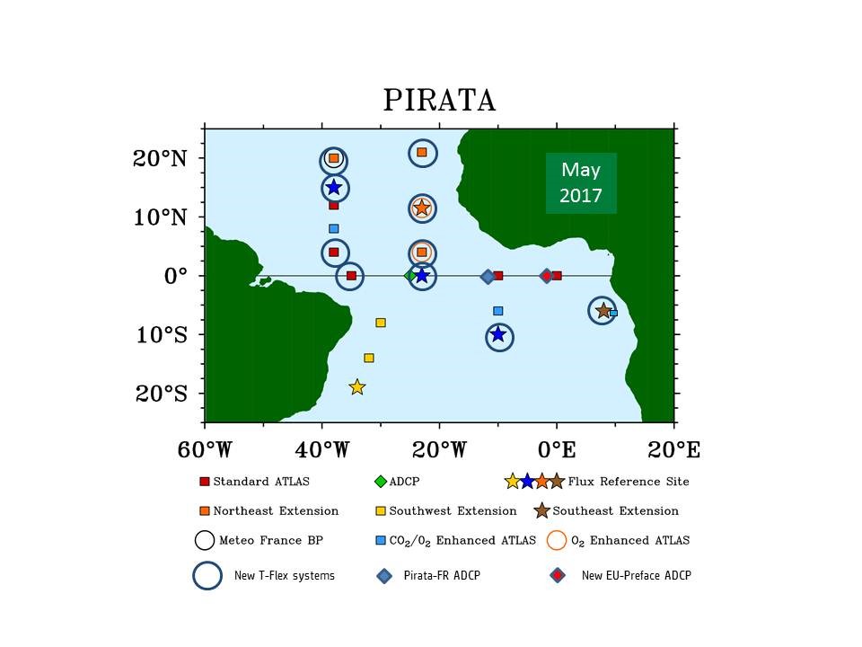
The meteo-oceanographic buoys of the PIRATA backbone of ATLAS buoys (red), Northeast Extension (orange), Southwest Extension (yellow), Southeast Extension pilot project (brown). Stars represent the Flux Reference sites, where buoys are equipped with longwave radiometer & currentmeter. Black circle buoy is equipped with a barometer (Meteo-France). Blue squares are buoys with CO2 sensors (IRD).Orange circles are buoys with O2 sensors (at 300m & 500m; GEOMAR). The three ADCP moorings are represented by diamonds (at 23°W, 10°W and 0°E, along the equator; IRD). T-Flex systems are surrounded by a blue circle.
The PIRATA program provides to the scientific community a free access to many data, summarized as follows:
- Real time data:
- Meteo-oceanic measurements using ATLAS buoys: The ATLAS or T-FLEX buoys are designed to measure surface meteorological variables (wind direction and speed, air temperature and humidity, rainfall and solar radiation) and hydrological sensors between the surface and 500m, namely 2 pressure sensors (at 300m and 500m), 11 temperature sensors (at the surface, 20m, 40m, 60m, 80m, 100m, 120m, 140m, 180m, 300m and 500m) and 4 conductivity sensors (at the surface, 20m, 40m and 120m).
- Some buoys are also equipped with currentmeter (at 12m), surface CO2 parameters sensors (at 3 buoys), and additional conductivity sensors in the upper layer (at 5m, 10m, 60m et 80m). The mean daily observations are transmitted by satellite (via Argos for ATLAS and via Iridium for T-FLEX) and are available in near real-time via Internet.
(see the following website).
- Delayed data:
- Current-meter measurements from moorings: ADCP (Acoustic Doppler Current Profiler) mooring continuously measures the two horizontal components of the current, from the surface to approximately 300m. The in situ measurements are available at a rate of one measurement every 4m from a depth of 16m.
- Oceanographic measurements obtained from ships: During each oceanographic campaign dedicated to PIRATA, meteo-oceanic measurements are carried out, which are principally : Current measurements (from 0 to 700m max.) using VM-ADCP acoustic Doppler current profilers; Surface temperature and salinity measurements using a thermosalinograph; Meteorological and navigational measurements using data acquisition units; Hydrological measurements with CTDO2 profiles (continuous pressure, temperature and salinity measurements between the surface and 2000m); Temperature measurements between the surface and approximately 800m with XBT probes.
- Measurements of chemical parameters (salinity, nutrients, chlorophyl pigments, CO2 parameters, eventually C13/O18) are also carried out at the surface and during CTDO2 profiles. Dedicated cruises are also opportunities for the deployment of ARGO profilers and surface SVP drifters, and CTD & XBT profiles data are transmitted in real time to CORIOLIS.
(see the ftp server).
The PIRATA network maintenance induces the realization (from the French side) of at least one dedicated oceanographic cruise per year, and at now 27 cruises have been carried out from 1997 (from 2005 to 2007, PIRATA cruises were associated to the cruises of the EGEE program, oceanographic part of the international AMMA program). In France, the maintenance of the 6 PIRATA network buoys located east of 23°W has to deal with two kinds of problems: 1) the problems due to vandalim in the Gulf of Guinea (linked to fishery activities; see http://www.brest.ird.fr/actualites/EGEE-3_bouees.htm), these problems considerably weakened from 2008, and 2) the problems due to piracy activitiy in the Gulf of Guinea, mostly from 2014. No more calls are allowed in any regional port, and the cruises are done in one leg (40 days) since 2015. Piracy also prevent us any research activity over the whole Northeastern part of the Gulf of Guinea.
PIRATA already allowed numerous studies carried out within several French laboratories, about air-sea fluxes, oceanic processes, and also data assimilation techniques, notably in the framework of the MERCATOR project.
Other web sites dedicated to PIRATA :
References :
Servain J., A. Busalacchi, A. Moura, M. McPhaden, G. Reverdin, M. Vianna, & S. Zebiak: A Pilot Research Moored Array in the Tropical Atlantic "PIRATA" ; The Bulletin of American Meteorological Society. 79, 2019-2031, 1998.
Bourlès, B., A. J. Busalacchi, E. Campos, F. Hernandez, R. Lumpkin, M.J. McPhaden, A.D. Moura, P. Nobre, S. Planton, J. Servain & J. Trotte, PIRATA (Pilot Research Moored Array in the Tropical Atlantic): Accomplishments of PIRATA: 1997-2005, Status and perspectives, Document prepared for a PIRATA review by CLIVAR -AIP - and OOPC, 89pp, avril 2006.
Bourlès, B., R. Lumpkin, M.J. McPhaden, F. Hernandez, P. Nobre, E. Campos, L.Yu, S. Planton, A.J. Busalacchi, A.D. Moura, J. Servain, and J. Trotte, The PIRATA program: history and accomplishments of the 10 first years tropical Atlantic observing system's backbone, Bulletin of the American Meteorological Society, 89(8), 1111-1125, 10.1175/2008BAMS2462.1, 2008.
Bourlès, B., M. Araujo, M. J. McPhaden, P. Brandt, G. R. Foltz, R. Lumpkin, H. Giordani, F. Hernandez, N. Lefevre, P. Nobre, E. Campos, R. Saravanan, J. Trotte-Duha, M. Dengler,J. Hahn, R. Hummels, J. F. Lubbecke, M. Rouault, L. Cotrim, A. Sutton, M. Jochum, and R. C. Perez, 2019: PIRATA: A sustained observing system for tropical Atlantic climate research and forecasting. Earth and Space Sci., 6, 577-616, doi/10.1029/2018EA000428

Bibliography:
A list of PIRATA references.
For more information, see the Bulletin of the American Meteorological Society cover story for August 2008.