


Measurements at São Tomé in the Gulf of Guinea
PIRATA-France maintained a tide-gauge at São Tomé from between 1997 and 2010.
A meteorological station was also maintained at São Tomé between 2003 and 2010, installed in the framework of the EGEE/AMMA program and included in the PIRATA network in 2009.
Visualize on a map (link in Google Map)
Due to technical failures and too weak funding & human powers, and following a recommendation of CSOA/INSU in 2015, these devices are not any more maintained.
São Tomé: Tide gauge
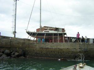
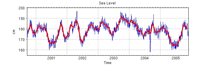
In 1989, a tide gauge has been installed by ORSTOM (renamed IRD in 1998) on the São Tomé Island (0°20'14"N 6°43'48"E) in the frame of climate research programs (TOGA, WOCE, CLIVAR). This tide gauge, linked to an Argos system for transmitting data in real time (mean sea level, sea temperature and barometric pressure), is part of the global observing network in the Tropical Atlantic and part ofhas been integrated in the PIRATA network since in1997. The tide gauge station has been GPS located for the international program GLOSS in December 2002. The tide gauge maintenance is was performed under the technological IRD reponsability responsability with the help on-site of the non-governmental organization "MARAPA". Data are were processed in LEGOS.
Due to a technical failure in August 2010 inducing the full replacing of the material, a new tide gauge station has been installed in 2013, functioning of which was not satisfying. All the material has been definitely retrieved in November 2016 and is now to CNRS/INSU.
Tide gauge data are collected in the Laboratoire d'Etudes en Géophysique et Océanographie Spatiales and available online:
- Real time data: available from the "Tide Gauges Network" website
- Delayed mode data after corrections (from 2000 to 2005)
The instrumental drift has been removed as well as the discontinuities in the timeseries related to the tide gauge site changes.
Information and data access are available through the SO ROSAME at LEGOS:
http://www.legos.obs-mip.fr/observations/rosame
ftp://ftp.legos.obs-mip.fr/pub/soa/niveau_mer/sao_tome
São Tomé: Meteorological station
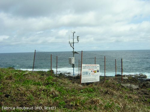
In October 2003, a meteorological station has been installed on the São Tomé Island in the frame of the EGEE/AMMA experiment. This station was part of PIRATA since the "Memorendum of Understanding" signed in February 2009 by the PIRATA organisms.
Raw data from this station (atmospheric pressure, precipitation, humidity, wind speed, wind direction, solar radiation, air temperature) and related information are available on the following ftp website.